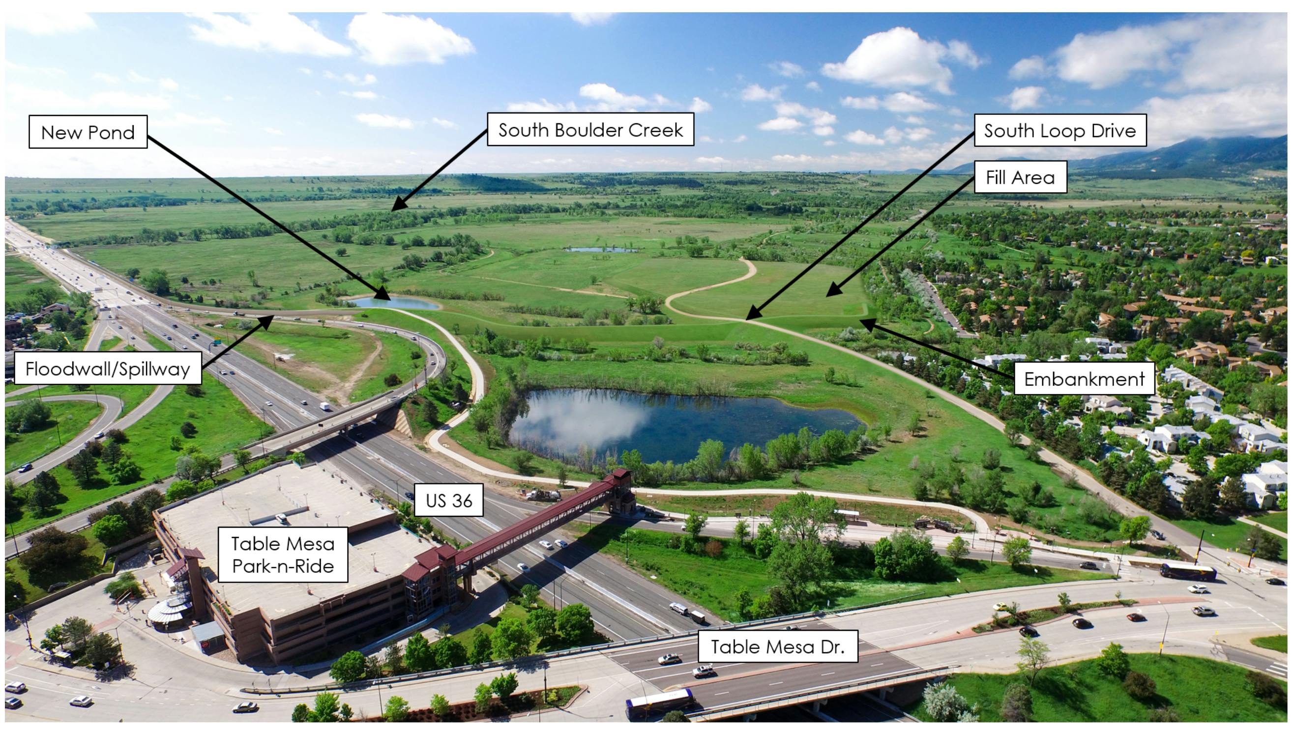
South Boulder Creek Flood Mitigation/CU South
The South Boulder Creek Flood Mitigation Project is a 17-year effort to study and take community/and advisory board feedback about how best to protect residences and parts of town that are at risk for catastrophic flooding from the South Boulder Creek drainage-way.
In February 2020, City Council indicated a preference for a 100-year flood protection because it has the least environmental impacts, the lowest cost and the greatest probability of meeting the project design criteria. Prior to making a formal flood design level recommendation on June 16, 2020, City Council has requested that staff update the public on the project status and seek input on the remaining items at this stage in the conceptual flood design. Specific topics of interest, including upstream detention viability and and open space and environmental mitigation, will be areas of focus at the June 3, 2020 Open Space Board of Trustees (OSBT) meeting.
The purpose of this Be Heard Boulder Project page is to give the Boulder community an opportunity to ask questions and share thoughts related to flood project tradeoffs, design or flood design information previously provided to council.
The following is a graphic that shows engagement related to the flood design between now and mid-June 2020.
The city knows there are lots of questions -- and varying opinions -- about the flood design. Some of these questions have been answered before, but others may be new. From April 29 through May 13, city staff will take your questions and share answers here.
First, we ask that you register with your real name. We are looking for transparent and constructive discourse here. This is a place for questions, not comments or opinions. An opportunity for that is available elsewhere on this site. Staff will endeavor to respond within five business days.
Second, we ask that you consider the trade-offs analysis the city has conducted. Here is a graph presented to council earlier this year:

-
Share How will the design and construction provide for enhanced wildlife passage under US36 beyond current concepts indicated in the preliminary design and construction? Many species migrate along streams for food and reproduction. How will hikers, runners, birdwatchers, and bicyclists navigate thru the site and past highway 36? How do you value the worth of the interconnected web of species living in the wet meadows? When I was on the city's wetlands advisory board years ago, scientific researchers agreed that it was impossible to recreate a wetland with the interdependencies of the the various species, soil types, plants, and microbes. Did you include in your models the following values of wetlands and native ecosystems: resiliency, the ability of plant communities to absorb and hold floodwaters and gradually release it; the ability of native plant communities to hold soil and prevent erosion and the degradation of water quality for wildlife and downstream users ; and the prevention of diseases spread by vectors such as fleas, mosquitos, bats, and wild birds. David Quammen in his book Spillover, mentions that biodiversity and larger areas biodiversity are keys to preventing spillovers of diseases that often occur when an ecosystem is simplified, disturbed, or merged with development. on Facebook Share How will the design and construction provide for enhanced wildlife passage under US36 beyond current concepts indicated in the preliminary design and construction? Many species migrate along streams for food and reproduction. How will hikers, runners, birdwatchers, and bicyclists navigate thru the site and past highway 36? How do you value the worth of the interconnected web of species living in the wet meadows? When I was on the city's wetlands advisory board years ago, scientific researchers agreed that it was impossible to recreate a wetland with the interdependencies of the the various species, soil types, plants, and microbes. Did you include in your models the following values of wetlands and native ecosystems: resiliency, the ability of plant communities to absorb and hold floodwaters and gradually release it; the ability of native plant communities to hold soil and prevent erosion and the degradation of water quality for wildlife and downstream users ; and the prevention of diseases spread by vectors such as fleas, mosquitos, bats, and wild birds. David Quammen in his book Spillover, mentions that biodiversity and larger areas biodiversity are keys to preventing spillovers of diseases that often occur when an ecosystem is simplified, disturbed, or merged with development. on X (formerly Twitter) Share How will the design and construction provide for enhanced wildlife passage under US36 beyond current concepts indicated in the preliminary design and construction? Many species migrate along streams for food and reproduction. How will hikers, runners, birdwatchers, and bicyclists navigate thru the site and past highway 36? How do you value the worth of the interconnected web of species living in the wet meadows? When I was on the city's wetlands advisory board years ago, scientific researchers agreed that it was impossible to recreate a wetland with the interdependencies of the the various species, soil types, plants, and microbes. Did you include in your models the following values of wetlands and native ecosystems: resiliency, the ability of plant communities to absorb and hold floodwaters and gradually release it; the ability of native plant communities to hold soil and prevent erosion and the degradation of water quality for wildlife and downstream users ; and the prevention of diseases spread by vectors such as fleas, mosquitos, bats, and wild birds. David Quammen in his book Spillover, mentions that biodiversity and larger areas biodiversity are keys to preventing spillovers of diseases that often occur when an ecosystem is simplified, disturbed, or merged with development. on Linkedin Email How will the design and construction provide for enhanced wildlife passage under US36 beyond current concepts indicated in the preliminary design and construction? Many species migrate along streams for food and reproduction. How will hikers, runners, birdwatchers, and bicyclists navigate thru the site and past highway 36? How do you value the worth of the interconnected web of species living in the wet meadows? When I was on the city's wetlands advisory board years ago, scientific researchers agreed that it was impossible to recreate a wetland with the interdependencies of the the various species, soil types, plants, and microbes. Did you include in your models the following values of wetlands and native ecosystems: resiliency, the ability of plant communities to absorb and hold floodwaters and gradually release it; the ability of native plant communities to hold soil and prevent erosion and the degradation of water quality for wildlife and downstream users ; and the prevention of diseases spread by vectors such as fleas, mosquitos, bats, and wild birds. David Quammen in his book Spillover, mentions that biodiversity and larger areas biodiversity are keys to preventing spillovers of diseases that often occur when an ecosystem is simplified, disturbed, or merged with development. link
How will the design and construction provide for enhanced wildlife passage under US36 beyond current concepts indicated in the preliminary design and construction? Many species migrate along streams for food and reproduction. How will hikers, runners, birdwatchers, and bicyclists navigate thru the site and past highway 36? How do you value the worth of the interconnected web of species living in the wet meadows? When I was on the city's wetlands advisory board years ago, scientific researchers agreed that it was impossible to recreate a wetland with the interdependencies of the the various species, soil types, plants, and microbes. Did you include in your models the following values of wetlands and native ecosystems: resiliency, the ability of plant communities to absorb and hold floodwaters and gradually release it; the ability of native plant communities to hold soil and prevent erosion and the degradation of water quality for wildlife and downstream users ; and the prevention of diseases spread by vectors such as fleas, mosquitos, bats, and wild birds. David Quammen in his book Spillover, mentions that biodiversity and larger areas biodiversity are keys to preventing spillovers of diseases that often occur when an ecosystem is simplified, disturbed, or merged with development.
3ouzel asked about 6 years agoThe proposed flood mitigation project has been found to have the least environmental impacts of the alternatives considered, including those to wetlands. Project design criteria includes replication of existing groundwater flow patterns to prevent upstream groundwater mounding, drying up downstream wetlands and/or other potential adverse impacts. The design has not been determined to effect wildlife passage under US36, although enhanced wildlife passage under US36 could be considered as possible environmental mitigation during the preliminary design phase of the project. No project impacts are anticipated to the existing South Boulder Creek trail and the US36 regional bike trail will be maintained in approximately its existing alignment. Environmental considerations associated with the existing levee, including its relationship to the floodplain, will be discussed at the June 3 Open Space Board of Trustees meeting.
-
Share How much floodwater will be detained with each of the 100, 200, and 500 year options? How much water could be detained in the gravel pit? on Facebook Share How much floodwater will be detained with each of the 100, 200, and 500 year options? How much water could be detained in the gravel pit? on X (formerly Twitter) Share How much floodwater will be detained with each of the 100, 200, and 500 year options? How much water could be detained in the gravel pit? on Linkedin Email How much floodwater will be detained with each of the 100, 200, and 500 year options? How much water could be detained in the gravel pit? link
How much floodwater will be detained with each of the 100, 200, and 500 year options? How much water could be detained in the gravel pit?
Harlin asked about 6 years agoThe table below provides the design detention volumes for each option:
Project Configuration
Detention Volume
(acre feet)
Option 1 (100-yr)
467
Option 2 (500-yr)
768
Option 3 (≈200-yr)
659
It is important to note that flood mitigation results from both detention and conveyance. The detention volume is one component of the design along with the conveyance capacity of the outlet works. The current configuration of the CU South property does not provide substantial storage without additional modification (i.e., construction of a berm/embankment) to detain water.
-
Share Why does the “cooperation” between the city and CU on flood mitigation plans involving CU South property appear to be extremely unbalanced in favor of CU, including plans to move forward with annexation of property and taking on financial responsibility for work on the land to make it easier and less expensive for CU to develop--for CU’s benefit--without any transparency on CU’s part regarding their development plans? Why is the city not demanding that CU provide details about their plans for development before the city agrees to annexation? on Facebook Share Why does the “cooperation” between the city and CU on flood mitigation plans involving CU South property appear to be extremely unbalanced in favor of CU, including plans to move forward with annexation of property and taking on financial responsibility for work on the land to make it easier and less expensive for CU to develop--for CU’s benefit--without any transparency on CU’s part regarding their development plans? Why is the city not demanding that CU provide details about their plans for development before the city agrees to annexation? on X (formerly Twitter) Share Why does the “cooperation” between the city and CU on flood mitigation plans involving CU South property appear to be extremely unbalanced in favor of CU, including plans to move forward with annexation of property and taking on financial responsibility for work on the land to make it easier and less expensive for CU to develop--for CU’s benefit--without any transparency on CU’s part regarding their development plans? Why is the city not demanding that CU provide details about their plans for development before the city agrees to annexation? on Linkedin Email Why does the “cooperation” between the city and CU on flood mitigation plans involving CU South property appear to be extremely unbalanced in favor of CU, including plans to move forward with annexation of property and taking on financial responsibility for work on the land to make it easier and less expensive for CU to develop--for CU’s benefit--without any transparency on CU’s part regarding their development plans? Why is the city not demanding that CU provide details about their plans for development before the city agrees to annexation? link
Why does the “cooperation” between the city and CU on flood mitigation plans involving CU South property appear to be extremely unbalanced in favor of CU, including plans to move forward with annexation of property and taking on financial responsibility for work on the land to make it easier and less expensive for CU to develop--for CU’s benefit--without any transparency on CU’s part regarding their development plans? Why is the city not demanding that CU provide details about their plans for development before the city agrees to annexation?
Brookie asked about 6 years agoProtecting City of Boulder and Boulder County residents from future flooding events is a primary driver of activity in this area. The city Utilities Department does not own the land or have utility easements for the proposed flood project. A portion of the land needed for flood mitigation is owned by the university. The land needed for flood mitigation is only available if and when the entire CU South property is annexed. There are currently no options to proceed with the flood mitigation dam without annexing CU South. Unfortunately, the timing of the city’s flood mitigation project and planning for future development on this site do not align. In light of the desire to move forward with flood control (accompanied by annexation) even in the absence of development plans from CU Boulder, the city and county adopted the CU South Guiding Principles in 2017 as part of an update to the Boulder Valley Comprehensive Plan. The guiding principles include concepts for controlling development like building height limits, an emphasis on residential uses, public access to trails and ways to address off-site transportation impacts (e.g., the number of trips per day, transit service). Further refinement of annexation details are in part dependent upon a flood design. Therefore, more in depth annexation negotiations and community engagement opportunities are anticipated after a flood design is chosen in June 2020.
-
Share These are follow up questions to the questions asked by Boulder Citizen, asked 8 days ago: Thank you for your response. I have some follow-up questions. 1. In terms of your answer to my previous question, Is any tax payer money going to CU for this flood mitigation project? Follow up #1: Am I correct in saying yes, Boulder citizens are paying CU Boulder 15 million to put the damn on their property. (Table 3, opinion on probable impact costs). Follow up #2: Why does the city say that CU Boulder is giving us the land if we are actually paying them 15 million? 2. Where is there consideration of the impact to surrounding neighborhoods (not only downstream)? I do not see an answer to this question in your response. Could you please highlight your response to this question? 3. In terms of your answer to this question: What alternatives exist for proceeding with the damn work without annexing the CU property? You say: There are no alternatives. Follow up #1: Where does it say in the Boulder Valley Comprehensive Plan guiding principles that there are no options to proceed with the flood mitigation dam without annexing CU South? Can you please provide a page and paragraph number or give the exact wording in the plan that says this? Follow up #2: Why does the city say that CU Boulder is giving us the land if the city is being forced to annex the land against the will of Boulder citizens? on Facebook Share These are follow up questions to the questions asked by Boulder Citizen, asked 8 days ago: Thank you for your response. I have some follow-up questions. 1. In terms of your answer to my previous question, Is any tax payer money going to CU for this flood mitigation project? Follow up #1: Am I correct in saying yes, Boulder citizens are paying CU Boulder 15 million to put the damn on their property. (Table 3, opinion on probable impact costs). Follow up #2: Why does the city say that CU Boulder is giving us the land if we are actually paying them 15 million? 2. Where is there consideration of the impact to surrounding neighborhoods (not only downstream)? I do not see an answer to this question in your response. Could you please highlight your response to this question? 3. In terms of your answer to this question: What alternatives exist for proceeding with the damn work without annexing the CU property? You say: There are no alternatives. Follow up #1: Where does it say in the Boulder Valley Comprehensive Plan guiding principles that there are no options to proceed with the flood mitigation dam without annexing CU South? Can you please provide a page and paragraph number or give the exact wording in the plan that says this? Follow up #2: Why does the city say that CU Boulder is giving us the land if the city is being forced to annex the land against the will of Boulder citizens? on X (formerly Twitter) Share These are follow up questions to the questions asked by Boulder Citizen, asked 8 days ago: Thank you for your response. I have some follow-up questions. 1. In terms of your answer to my previous question, Is any tax payer money going to CU for this flood mitigation project? Follow up #1: Am I correct in saying yes, Boulder citizens are paying CU Boulder 15 million to put the damn on their property. (Table 3, opinion on probable impact costs). Follow up #2: Why does the city say that CU Boulder is giving us the land if we are actually paying them 15 million? 2. Where is there consideration of the impact to surrounding neighborhoods (not only downstream)? I do not see an answer to this question in your response. Could you please highlight your response to this question? 3. In terms of your answer to this question: What alternatives exist for proceeding with the damn work without annexing the CU property? You say: There are no alternatives. Follow up #1: Where does it say in the Boulder Valley Comprehensive Plan guiding principles that there are no options to proceed with the flood mitigation dam without annexing CU South? Can you please provide a page and paragraph number or give the exact wording in the plan that says this? Follow up #2: Why does the city say that CU Boulder is giving us the land if the city is being forced to annex the land against the will of Boulder citizens? on Linkedin Email These are follow up questions to the questions asked by Boulder Citizen, asked 8 days ago: Thank you for your response. I have some follow-up questions. 1. In terms of your answer to my previous question, Is any tax payer money going to CU for this flood mitigation project? Follow up #1: Am I correct in saying yes, Boulder citizens are paying CU Boulder 15 million to put the damn on their property. (Table 3, opinion on probable impact costs). Follow up #2: Why does the city say that CU Boulder is giving us the land if we are actually paying them 15 million? 2. Where is there consideration of the impact to surrounding neighborhoods (not only downstream)? I do not see an answer to this question in your response. Could you please highlight your response to this question? 3. In terms of your answer to this question: What alternatives exist for proceeding with the damn work without annexing the CU property? You say: There are no alternatives. Follow up #1: Where does it say in the Boulder Valley Comprehensive Plan guiding principles that there are no options to proceed with the flood mitigation dam without annexing CU South? Can you please provide a page and paragraph number or give the exact wording in the plan that says this? Follow up #2: Why does the city say that CU Boulder is giving us the land if the city is being forced to annex the land against the will of Boulder citizens? link
These are follow up questions to the questions asked by Boulder Citizen, asked 8 days ago: Thank you for your response. I have some follow-up questions. 1. In terms of your answer to my previous question, Is any tax payer money going to CU for this flood mitigation project? Follow up #1: Am I correct in saying yes, Boulder citizens are paying CU Boulder 15 million to put the damn on their property. (Table 3, opinion on probable impact costs). Follow up #2: Why does the city say that CU Boulder is giving us the land if we are actually paying them 15 million? 2. Where is there consideration of the impact to surrounding neighborhoods (not only downstream)? I do not see an answer to this question in your response. Could you please highlight your response to this question? 3. In terms of your answer to this question: What alternatives exist for proceeding with the damn work without annexing the CU property? You say: There are no alternatives. Follow up #1: Where does it say in the Boulder Valley Comprehensive Plan guiding principles that there are no options to proceed with the flood mitigation dam without annexing CU South? Can you please provide a page and paragraph number or give the exact wording in the plan that says this? Follow up #2: Why does the city say that CU Boulder is giving us the land if the city is being forced to annex the land against the will of Boulder citizens?
Boulder Citizen asked about 6 years agoNo taxpayer money is going to CU for the flood mitigation project. The project will be paid for by Stormwater and Flood Management Utility rate payers.
Follow-up #1. No. Project costs are paid for through utility bills, not through taxes.
Follow-up #2: The $15 million is an estimate of existing structures or features that will be impacted by the flood mitigation project and is unrelated to the 80 acres of land the university has committed to convey to the city for construction of a flood mitigation project or to be used for open space mitigation related to the project. If CU did not convey the 80 acres, the city would have to purchase that as an additional project cost.
The flood mitigation project will address flooding in the West Valley overflow and will not address flooding in surrounding neighborhoods. Impacts of CU South annexation to surrounding neighborhoods will be considered as part of the annexation process. Annexation agreement negotiations will be guided by the CU South Guiding Principles and will provide opportunities to influence the annexation terms through city boards and the City Council meetings. The schedule and process for these meetings will be further refined once a South Boulder Creek flood mitigation design level is chosen, which is anticipated in June 2020.
Additionally, a multi-modal transportation and access study will be completed prior to annexation to determine necessary improvements, appropriate points of access, performance standards (e.g., trip budget) and other related topics. City staff will coordinate with CDOT during and after the study and each impacted neighborhood will be consulted throughout that process. The study can be completed once a flood mitigation concept is chosen and more is known about the related impacts to the site.
Follow-up #1: The city Utilities Department does not own the land or have utility easements for the proposed flood project. The university owns a portion of the property. Page 3, paragraph 1.b. of the Boulder Valley Comprehensive Plan CU South Guiding Principles states “Specific real property ownership, easements, and/or agreements will be established during annexation for the area necessary for floodwater improvements and other uses...” The related figures depict the 129 acres of developable land required by the university in any acceptable flood alternative.
Follow-up #2: Boulder City Council representatives will ultimately vote on whether to accept the negotiated annexation agreement on behalf of the City of Boulder.
-
Share In 2001, Gilbert White, Boulder’s most eminent flood management expert, chaired an independent commission that reviewed the CU South property and Prof. White concluded that the site was not appropriate for the level of development CU has proposed because it is in the flood plain of South Boulder Creek. Why has the City abandoned the guidance of Gilbert White? What has changed since he conducted his analysis? on Facebook Share In 2001, Gilbert White, Boulder’s most eminent flood management expert, chaired an independent commission that reviewed the CU South property and Prof. White concluded that the site was not appropriate for the level of development CU has proposed because it is in the flood plain of South Boulder Creek. Why has the City abandoned the guidance of Gilbert White? What has changed since he conducted his analysis? on X (formerly Twitter) Share In 2001, Gilbert White, Boulder’s most eminent flood management expert, chaired an independent commission that reviewed the CU South property and Prof. White concluded that the site was not appropriate for the level of development CU has proposed because it is in the flood plain of South Boulder Creek. Why has the City abandoned the guidance of Gilbert White? What has changed since he conducted his analysis? on Linkedin Email In 2001, Gilbert White, Boulder’s most eminent flood management expert, chaired an independent commission that reviewed the CU South property and Prof. White concluded that the site was not appropriate for the level of development CU has proposed because it is in the flood plain of South Boulder Creek. Why has the City abandoned the guidance of Gilbert White? What has changed since he conducted his analysis? link
In 2001, Gilbert White, Boulder’s most eminent flood management expert, chaired an independent commission that reviewed the CU South property and Prof. White concluded that the site was not appropriate for the level of development CU has proposed because it is in the flood plain of South Boulder Creek. Why has the City abandoned the guidance of Gilbert White? What has changed since he conducted his analysis?
PLAN Boulder County asked about 6 years agoWork subsequent to 2001 has informed the current project approach. Specifically, floodplain mapping accepted by FEMA in 2010 describes the West Valley flood risk discussed in the South Boulder Creek Major Drainageway Plan that was accepted by council in 2015. In 2017 the city and county incorporated these floodplain considerations in the Boulder Valley Comprehensive Plan CU South Guiding Principles that allow for flood mitigation on and guide the development of the CU South property.
-
Share What is different about the 500-year design that makes CDOT unwilling to accept it? on Facebook Share What is different about the 500-year design that makes CDOT unwilling to accept it? on X (formerly Twitter) Share What is different about the 500-year design that makes CDOT unwilling to accept it? on Linkedin Email What is different about the 500-year design that makes CDOT unwilling to accept it? link
What is different about the 500-year design that makes CDOT unwilling to accept it?
PLAN Boulder County asked about 6 years agoThe flood mitigation project’s design criteria require no adverse impacts to downstream property owners, including the US highway 36 bridge. This means a successful design must match existing hydraulic conditions through the bridge. The 500-yr event flows and depths increase through the US36 bridge and therefore do not meet these criteria.
-
Share Hello, I have 6 questions, below. I hope it's ok that I'm submitting them in a group. I appreciate your help. Frances 1. Historic flows were used for the designs. Why wasn’t the increased flood intensity and amount, which is expected due to climate change, factored into the designs and into the discussion? 2. Will you please provide a map of the City showing the amount of development/structures in each drainage and the levels of flood protection in each of those drainages? If possible, would you also give a rough estimate of the cost and possibilities for creating flood mitigation structures/measures in each drainage? 3. The Variant 1 designs require a dam to be placed between the Highway 36 embankment and the floodwall that runs parallel to it. CDOT has advised that no above-ground structures can be placed in its right-of-way. (a) Why is the Utility Department pursuing these designs without first obtaining written approval from CDOT, (b) what is the City’s plan for flood mitigation if CDOT maintains its position that there can be no above-ground structures within its right-of-way, and (c) is the City looking at alternatives; if so, what are the alternatives? 4. Why are there no costs or mention of Viele Channel in any of the documents provided to WRAB or City Council, when discharging water detained behind the flood control structure requires that the Viele Channel undergo an extensive rehabilitation effort to remove vegetation and sediment in order to minimize the risk of flooding if this channel overflows? What are the approximate costs for that work? 5. How were the acreages of Threatened and Endangered Species Habitat determined that are shown on Table 2 in the April WRAB information packet? How many acres of Prebles Meadow Jumping Mouse habitat and how many acres of Ute Ladies’ Tresses Orchid habitat are included for each option? How many of those acres are associated with the floodwall compared to the earth fill? 6. Since the April WRAB information packet states on page 78 that FEMA issued a Letter of Map Revision for the Highway 36 widening, does this mean that FEMA has approved Highway 36 as a flood control structure; if so, why does the design propose building a floodwall parallel to the highway? on Facebook Share Hello, I have 6 questions, below. I hope it's ok that I'm submitting them in a group. I appreciate your help. Frances 1. Historic flows were used for the designs. Why wasn’t the increased flood intensity and amount, which is expected due to climate change, factored into the designs and into the discussion? 2. Will you please provide a map of the City showing the amount of development/structures in each drainage and the levels of flood protection in each of those drainages? If possible, would you also give a rough estimate of the cost and possibilities for creating flood mitigation structures/measures in each drainage? 3. The Variant 1 designs require a dam to be placed between the Highway 36 embankment and the floodwall that runs parallel to it. CDOT has advised that no above-ground structures can be placed in its right-of-way. (a) Why is the Utility Department pursuing these designs without first obtaining written approval from CDOT, (b) what is the City’s plan for flood mitigation if CDOT maintains its position that there can be no above-ground structures within its right-of-way, and (c) is the City looking at alternatives; if so, what are the alternatives? 4. Why are there no costs or mention of Viele Channel in any of the documents provided to WRAB or City Council, when discharging water detained behind the flood control structure requires that the Viele Channel undergo an extensive rehabilitation effort to remove vegetation and sediment in order to minimize the risk of flooding if this channel overflows? What are the approximate costs for that work? 5. How were the acreages of Threatened and Endangered Species Habitat determined that are shown on Table 2 in the April WRAB information packet? How many acres of Prebles Meadow Jumping Mouse habitat and how many acres of Ute Ladies’ Tresses Orchid habitat are included for each option? How many of those acres are associated with the floodwall compared to the earth fill? 6. Since the April WRAB information packet states on page 78 that FEMA issued a Letter of Map Revision for the Highway 36 widening, does this mean that FEMA has approved Highway 36 as a flood control structure; if so, why does the design propose building a floodwall parallel to the highway? on X (formerly Twitter) Share Hello, I have 6 questions, below. I hope it's ok that I'm submitting them in a group. I appreciate your help. Frances 1. Historic flows were used for the designs. Why wasn’t the increased flood intensity and amount, which is expected due to climate change, factored into the designs and into the discussion? 2. Will you please provide a map of the City showing the amount of development/structures in each drainage and the levels of flood protection in each of those drainages? If possible, would you also give a rough estimate of the cost and possibilities for creating flood mitigation structures/measures in each drainage? 3. The Variant 1 designs require a dam to be placed between the Highway 36 embankment and the floodwall that runs parallel to it. CDOT has advised that no above-ground structures can be placed in its right-of-way. (a) Why is the Utility Department pursuing these designs without first obtaining written approval from CDOT, (b) what is the City’s plan for flood mitigation if CDOT maintains its position that there can be no above-ground structures within its right-of-way, and (c) is the City looking at alternatives; if so, what are the alternatives? 4. Why are there no costs or mention of Viele Channel in any of the documents provided to WRAB or City Council, when discharging water detained behind the flood control structure requires that the Viele Channel undergo an extensive rehabilitation effort to remove vegetation and sediment in order to minimize the risk of flooding if this channel overflows? What are the approximate costs for that work? 5. How were the acreages of Threatened and Endangered Species Habitat determined that are shown on Table 2 in the April WRAB information packet? How many acres of Prebles Meadow Jumping Mouse habitat and how many acres of Ute Ladies’ Tresses Orchid habitat are included for each option? How many of those acres are associated with the floodwall compared to the earth fill? 6. Since the April WRAB information packet states on page 78 that FEMA issued a Letter of Map Revision for the Highway 36 widening, does this mean that FEMA has approved Highway 36 as a flood control structure; if so, why does the design propose building a floodwall parallel to the highway? on Linkedin Email Hello, I have 6 questions, below. I hope it's ok that I'm submitting them in a group. I appreciate your help. Frances 1. Historic flows were used for the designs. Why wasn’t the increased flood intensity and amount, which is expected due to climate change, factored into the designs and into the discussion? 2. Will you please provide a map of the City showing the amount of development/structures in each drainage and the levels of flood protection in each of those drainages? If possible, would you also give a rough estimate of the cost and possibilities for creating flood mitigation structures/measures in each drainage? 3. The Variant 1 designs require a dam to be placed between the Highway 36 embankment and the floodwall that runs parallel to it. CDOT has advised that no above-ground structures can be placed in its right-of-way. (a) Why is the Utility Department pursuing these designs without first obtaining written approval from CDOT, (b) what is the City’s plan for flood mitigation if CDOT maintains its position that there can be no above-ground structures within its right-of-way, and (c) is the City looking at alternatives; if so, what are the alternatives? 4. Why are there no costs or mention of Viele Channel in any of the documents provided to WRAB or City Council, when discharging water detained behind the flood control structure requires that the Viele Channel undergo an extensive rehabilitation effort to remove vegetation and sediment in order to minimize the risk of flooding if this channel overflows? What are the approximate costs for that work? 5. How were the acreages of Threatened and Endangered Species Habitat determined that are shown on Table 2 in the April WRAB information packet? How many acres of Prebles Meadow Jumping Mouse habitat and how many acres of Ute Ladies’ Tresses Orchid habitat are included for each option? How many of those acres are associated with the floodwall compared to the earth fill? 6. Since the April WRAB information packet states on page 78 that FEMA issued a Letter of Map Revision for the Highway 36 widening, does this mean that FEMA has approved Highway 36 as a flood control structure; if so, why does the design propose building a floodwall parallel to the highway? link
Hello, I have 6 questions, below. I hope it's ok that I'm submitting them in a group. I appreciate your help. Frances 1. Historic flows were used for the designs. Why wasn’t the increased flood intensity and amount, which is expected due to climate change, factored into the designs and into the discussion? 2. Will you please provide a map of the City showing the amount of development/structures in each drainage and the levels of flood protection in each of those drainages? If possible, would you also give a rough estimate of the cost and possibilities for creating flood mitigation structures/measures in each drainage? 3. The Variant 1 designs require a dam to be placed between the Highway 36 embankment and the floodwall that runs parallel to it. CDOT has advised that no above-ground structures can be placed in its right-of-way. (a) Why is the Utility Department pursuing these designs without first obtaining written approval from CDOT, (b) what is the City’s plan for flood mitigation if CDOT maintains its position that there can be no above-ground structures within its right-of-way, and (c) is the City looking at alternatives; if so, what are the alternatives? 4. Why are there no costs or mention of Viele Channel in any of the documents provided to WRAB or City Council, when discharging water detained behind the flood control structure requires that the Viele Channel undergo an extensive rehabilitation effort to remove vegetation and sediment in order to minimize the risk of flooding if this channel overflows? What are the approximate costs for that work? 5. How were the acreages of Threatened and Endangered Species Habitat determined that are shown on Table 2 in the April WRAB information packet? How many acres of Prebles Meadow Jumping Mouse habitat and how many acres of Ute Ladies’ Tresses Orchid habitat are included for each option? How many of those acres are associated with the floodwall compared to the earth fill? 6. Since the April WRAB information packet states on page 78 that FEMA issued a Letter of Map Revision for the Highway 36 widening, does this mean that FEMA has approved Highway 36 as a flood control structure; if so, why does the design propose building a floodwall parallel to the highway?
Frances asked about 6 years agoTwo separate sets of regulatory standards apply to the project, one for the floodplain and one for dam safety and design. Regulatory standards for floodplain mapping and flood mitigation do not require an allowance for climate change. However, city staff are evaluating if and how a voluntary climate change allowance might be incorporated into the design. The state engineer’s office has regulatory jurisdiction over the dam structure and does require a climate change allowance for design of high hazard dams, and such an allowance is being incorporated into the South Boulder Creek flood mitigation design.
The best way to identify structures currently located in a floodplain is through the City’s flood hazards map. Proposed projects currently identified in each drainage are included on the city’s flood information webpage. Attachment C to the April 20, 2020 Water Resources Advisory Board materials (page 209 of 242) provides cost estimates related to the broader Stormwater and Flood Management Utility. Each drainageway is evaluated through a “lifecycle” of mapping, mitigation planning, design and construction and each drainageway is at a different point in the lifecycle. Therefore, existing mitigation cost estimates for all drainages in the city are a work in progress and potentially understate the overall actual need. Updated cost estimates for the various drainageways are continuously being developed and will be a topic included in the Comprehensive Flood and Stormwater Master Plan update taking place in 2020 and 2021.
The city has held preliminary discussions with CDOT about the project but won’t be able to obtain more definitive determinations until staff presents the alternative council chooses and enough associated design work, including hydraulic analysis at the US36 bridge, for their input and review. As with any project, the city would need to reevaluate the proposed flood mitigation approach if required permits or approvals were denied.
Maintenance of Viele channel is included in the ongoing Stormwater and Flood Management Utility as one of the 16 major drainage ways in Boulder and is planned for irrespective of the flood design project. Post construction, the Viele channel would be maintained as required to provide adequate capacity for the flood mitigation outlet works.
Current environmental impacts were estimated by overlaying existing Geographic Information Systems (GIS) data, including environmental information and environmental surveys of the project area, with the proposed project footprint(s). The table below provides a summary of the resulting environmental impacts, including the impacts to Threatened and Endangered species habitat. The work done to date is adequate for comparison purposes at the conceptual design level and will be further refined as design proceeds.
Potential Environmental Impacts
Project Alternative
Wetlands
(acres)
Open Water
(acres)
Total Open Water and Wetlands
(acres)
Total Threatened and Endangered Species Habitat
(acres)
Option 1
(100-yr)
4.8
2.6
7.4
0.9
Option 2
(500-yr)
7.1
2.6
9.7
5.0
Option 3
(200-yr)
8.9
2.6
11.5*
5.0
Note: Figures are rounded to the nearest 1/10th of an acre
* Placement of fill is considered an impact in USACE 404 permitting, whereas inundation with water is not considered an impact. Because fill placement is unique to each of the alternatives based on the non-inundated property available, the 200-yr storm has more land available for fill, including more wetlands, thus the larger area of impact.
US 36 is not an approved flood control structure. The FEMA letter associated with the highway widening documents changes to the SBC floodplain resulting from the US36 widening project. These changes do not prevent US36 from overtopping during a 100-yr flood and do not provide flood benefits for the West Valley area that the proposed flood mitigation project is designed to protect.
-
Share During the a recent city council study session, city council members expressed concerns based on staff comments that CDOT might not approve plans for 500-year protection because of increased SBC flows under the US 36 bridge. Council members stated such concerns were a major reason for rejecting the 500-year plan. In the past, there was grievous miscommunication between the city staff and CDOT regarding the use of CDOT right-of-way along US 36. I therefore made requests to city staffmembers Joe Taddeucci and Brandon Coleman for hard evidence that CDOT would not approve the 500-year plan. I also requested such information from CDOT, including a formal CORA request to CDOT. I have received nothing that would support city staff's statements that CDOT might not approve the 500-year plan. In fact, the City’s report states that the 500-year plan may not cause any negative impacts. "The 108-inch-diameter outlet would increase peak flows through the US36 bridge by about 6 percent but would not cause additional flooding downstream of South Boulder Road. It is possible that the increases in flow through the bridge may not cause negative impacts (i.e., scour) or that negative impacts could be mitigated by installing scour protection through the bridge." Please provide hard evidence that CDOT would not approve plans for protection from a 500-year flood. on Facebook Share During the a recent city council study session, city council members expressed concerns based on staff comments that CDOT might not approve plans for 500-year protection because of increased SBC flows under the US 36 bridge. Council members stated such concerns were a major reason for rejecting the 500-year plan. In the past, there was grievous miscommunication between the city staff and CDOT regarding the use of CDOT right-of-way along US 36. I therefore made requests to city staffmembers Joe Taddeucci and Brandon Coleman for hard evidence that CDOT would not approve the 500-year plan. I also requested such information from CDOT, including a formal CORA request to CDOT. I have received nothing that would support city staff's statements that CDOT might not approve the 500-year plan. In fact, the City’s report states that the 500-year plan may not cause any negative impacts. "The 108-inch-diameter outlet would increase peak flows through the US36 bridge by about 6 percent but would not cause additional flooding downstream of South Boulder Road. It is possible that the increases in flow through the bridge may not cause negative impacts (i.e., scour) or that negative impacts could be mitigated by installing scour protection through the bridge." Please provide hard evidence that CDOT would not approve plans for protection from a 500-year flood. on X (formerly Twitter) Share During the a recent city council study session, city council members expressed concerns based on staff comments that CDOT might not approve plans for 500-year protection because of increased SBC flows under the US 36 bridge. Council members stated such concerns were a major reason for rejecting the 500-year plan. In the past, there was grievous miscommunication between the city staff and CDOT regarding the use of CDOT right-of-way along US 36. I therefore made requests to city staffmembers Joe Taddeucci and Brandon Coleman for hard evidence that CDOT would not approve the 500-year plan. I also requested such information from CDOT, including a formal CORA request to CDOT. I have received nothing that would support city staff's statements that CDOT might not approve the 500-year plan. In fact, the City’s report states that the 500-year plan may not cause any negative impacts. "The 108-inch-diameter outlet would increase peak flows through the US36 bridge by about 6 percent but would not cause additional flooding downstream of South Boulder Road. It is possible that the increases in flow through the bridge may not cause negative impacts (i.e., scour) or that negative impacts could be mitigated by installing scour protection through the bridge." Please provide hard evidence that CDOT would not approve plans for protection from a 500-year flood. on Linkedin Email During the a recent city council study session, city council members expressed concerns based on staff comments that CDOT might not approve plans for 500-year protection because of increased SBC flows under the US 36 bridge. Council members stated such concerns were a major reason for rejecting the 500-year plan. In the past, there was grievous miscommunication between the city staff and CDOT regarding the use of CDOT right-of-way along US 36. I therefore made requests to city staffmembers Joe Taddeucci and Brandon Coleman for hard evidence that CDOT would not approve the 500-year plan. I also requested such information from CDOT, including a formal CORA request to CDOT. I have received nothing that would support city staff's statements that CDOT might not approve the 500-year plan. In fact, the City’s report states that the 500-year plan may not cause any negative impacts. "The 108-inch-diameter outlet would increase peak flows through the US36 bridge by about 6 percent but would not cause additional flooding downstream of South Boulder Road. It is possible that the increases in flow through the bridge may not cause negative impacts (i.e., scour) or that negative impacts could be mitigated by installing scour protection through the bridge." Please provide hard evidence that CDOT would not approve plans for protection from a 500-year flood. link
During the a recent city council study session, city council members expressed concerns based on staff comments that CDOT might not approve plans for 500-year protection because of increased SBC flows under the US 36 bridge. Council members stated such concerns were a major reason for rejecting the 500-year plan. In the past, there was grievous miscommunication between the city staff and CDOT regarding the use of CDOT right-of-way along US 36. I therefore made requests to city staffmembers Joe Taddeucci and Brandon Coleman for hard evidence that CDOT would not approve the 500-year plan. I also requested such information from CDOT, including a formal CORA request to CDOT. I have received nothing that would support city staff's statements that CDOT might not approve the 500-year plan. In fact, the City’s report states that the 500-year plan may not cause any negative impacts. "The 108-inch-diameter outlet would increase peak flows through the US36 bridge by about 6 percent but would not cause additional flooding downstream of South Boulder Road. It is possible that the increases in flow through the bridge may not cause negative impacts (i.e., scour) or that negative impacts could be mitigated by installing scour protection through the bridge." Please provide hard evidence that CDOT would not approve plans for protection from a 500-year flood.
B. Binder asked about 6 years agoAsking permitting agencies to speculate in writing about specifics of what they might or might not approve before such detail is available to do so would be a dramatic departure from normal project process and would not be conducive to efficient agency approvals. If such out-of-process documentation will be a requirement of the project going forward, staff would not recommend proceeding. Conditions that will be fundamental to approval for any alternative presented to CDOT involving the US36 bridge cannot be met for the 200- and 500-year flood levels.
-
Share What is included in "total project cost?" Are Phase 2 and 3 included? Is long-term maintenance included? What is counted as an "environmental impact? on Facebook Share What is included in "total project cost?" Are Phase 2 and 3 included? Is long-term maintenance included? What is counted as an "environmental impact? on X (formerly Twitter) Share What is included in "total project cost?" Are Phase 2 and 3 included? Is long-term maintenance included? What is counted as an "environmental impact? on Linkedin Email What is included in "total project cost?" Are Phase 2 and 3 included? Is long-term maintenance included? What is counted as an "environmental impact? link
What is included in "total project cost?" Are Phase 2 and 3 included? Is long-term maintenance included? What is counted as an "environmental impact?
Harlin asked about 6 years agoThe project costs include costs for construction of Phase 1 from the South Boulder Creek Master Plan. This includes the direct costs of constructing the flood mitigation structure (detention facility), the earth fill cost to provide 129 acres of PUB land use area, and estimated cost of impacts to existing university facilities. These line items in the table below are delineated because earth fill is not required for the flood mitigation protection but needed to offset land use impacts from creation of flood detention.
Opinion of Probable Construction Cost
Project Components
Option 1
(100-yr)
Option 2
(500-yr)
Option 3
(200-yr)
Regional Flood Detention
$41M
$47M
$46M
Earth Fill
$10M
$34M
$32M
SubTotal
$51M
$81M
$78M
CU Impacts (1)
$15M
$15M
$15M
Total
$66M
$96M
$93M
Note: Figures have been rounded to the nearest million dollars
(1) Includes impacts to CU Tennis Courts, South Loop Drive, Warehouse, Utilities Connections, Recreation Fields. Estimated costs/impacts will be refined as the flood mitigation project progresses through the design process and finalized through the annexation process
Long term operation and maintenance would typically be estimated at 0.5% to 1% per year of initial construction cost of dam features and is not included in cost tables but is within the margin of accuracy of the estimates. All alternatives would have similar features and would require similar maintenance.
Environmental impacts are based on the project footprint (area underneath a design element) over ecologically sensitive areas (i.e., threatened and endangered species habitat, wetland, etc.). The disturbance area used for the project footprint includes an allowance for construction access and staging. Any additional construction access roads and staging areas, if needed, would be determined once a design concept is selected and construction drawings and specifications are developed.
-
Share How will transportation access to the site be decided? Will Tantra lakes be consulted? Will CDOT be consulted? When will this happen? on Facebook Share How will transportation access to the site be decided? Will Tantra lakes be consulted? Will CDOT be consulted? When will this happen? on X (formerly Twitter) Share How will transportation access to the site be decided? Will Tantra lakes be consulted? Will CDOT be consulted? When will this happen? on Linkedin Email How will transportation access to the site be decided? Will Tantra lakes be consulted? Will CDOT be consulted? When will this happen? link
How will transportation access to the site be decided? Will Tantra lakes be consulted? Will CDOT be consulted? When will this happen?
PLAN Boulder County asked about 6 years agoA multi-modal transportation and access study will be completed prior to annexation to determine necessary improvements, appropriate points of access, performance standards (e.g., trip budget) and other related topics. City staff will coordinate with CDOT during and after the study and each impacted neighborhood will be consulted throughout that process. We anticipate the transportation study being completed after the flood mitigation project is selected in June 2020, given that the different concepts impact the site differently (e.g., perimeter access points).
Documents
-
 Water Resources Advisory Board (WRAB) Meeting Memo, April 20, 2020
-
OSBT Past Motions (July 11, 2018 and Sept. 11, 2019) related to SBC Flood Mitigation (110 KB) (pdf)
-
City Council Study Session Summary, Feb, 25, 2020 (146 KB) (pdf)
-
Presentation, May 20 Community Information Session (10.6 MB) (pdf)
-
Open Space Board of Trustees Project Technical Data Packet (38.2 MB) (pdf)

Photos/Drawings
Who's Listening


Key Dates
-
May 07 2020
-
May 20 2020
-
June 03 2020
-
June 16 2020